My latest Post.

This view,this beauty
A tear unbidden
Creeps into my eye.

My stay is short
But I shall return to this place
If only my life is long enough.

Such beauty
Gazing upon it
I hope my years are many.

Bokusui Wakayama.

Wednesday, September 5, 2012

A "Claytons" Blog.

Bottle of Claytons.
   "So whats a Claytons Blog anyway"? you're asking yourself. Well it has nothing to do with the Great Outdoors (unless you have packed a bottle in with your gear. But, as it's non-alcoholic,why would you want to take a bottle of this stuff along with you anyway?). To explain, I shall let the guys at Wikipedia put you in the frame - take note of the sentence "...the drink you have when you're not having a drink". If you're still confused, let me explain; this is a blog I'm composing that's not a blog.
   I have discovered that it has been 2-months since my last contribution to the blogging community. I must apologize for this. I appreciate some of you guys out there have become insomniacs as a result of this dry-spell, but there is a reason why (well actually there are several). This summer has been one of the most severest in Japans history (or since weather/climate information has been recorded) and, after a close-call a month or so ago, I decided to err on the side of caution and go-out on short expeditions only. Then there was work (that horrible 4-letter word) that has kept me off the scene. But, it's not to say I have forgotten about you guys. I have a couple of blogs in the pipeline that I am working-on (actually I was all set last Saturday,1st Sept', to complete my research,when "Mother Nature" intervened and it pissed-with-rain). So, let me assure you, I haven't fallen-off the face of the Earth
Map/Location.
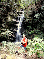
   And, to prove I am still in the "Land-of-the-Living", here I am at precisely (or thereabouts) 09:35 on Sunday 2nd September 2012. I look good, don't I? Well actually I was knackered. At this point I was 37km into a 91-km ride. But, for the previous 1km, I had to lug my bike (and myself as well) up a creek (oh the joys of off-road cycling). It was close to this point, about 6-weeks ago, that I collapsed with heat-stroke and had to cool-down (it was only 10:30 and already in the mid-30c).
   In my post, "In Search of Shoryaku-ji Temple", I mentioned "....the track leading me to this spot looked very-inviting and may require further investigation on a later visit". Well, this is that trip. I have been planning this outing for a few weeks now but, thanks to one thing or another, I just never got-around to it. 
Map/Location.

    I always make a bee-line for this spot, on the border of Nara Park (it's a 2.5-hour x 28km ride to get to this point), where I can take on some water and munch on a banana before setting off. Today's course, Nara Park to the Kizugawa Cycleway (this is a great 'site for logging outings as it records elevation, distance & course, as-well-as posting images) is undulating and with the first 10km being relatively flat, I am aware of some hilly terrain ahead. As I am in "tourist mode", I want to take-in as much of the surrounding scenery as I can, like in this image on the right.
Map/Location.
I am passing-through the settlement of Kitatsubaocho and the rice is beginning to brown off before it's harvested, in about another months time. This area is used mainly for rice and is a spectacular sight, regardless of what stage the rice is at.
As I begin to put my camera away, I discover this set of Jizo behind me. One will find these anywhere/everywhere and are a delight to encounter.
Map/Location.

1,500-meters up the road is the magnificent complex of Shoryaku-ji Temple. Unlike the last time I was here, where I spent the best part of 2-hours, this time I am just passing-through. I have some uncharted territory ahead and I needed to be prepared for what was about to greet me and, believe me, I was in for a grunt of a climb. 
Map/Location.
Out of the forest and back onto a decent sealed road before my next destination - a 185-year old Japanese tea-House. If you check on the map link (just below the image) you will see how isolated this place is. The proprietor is the 6th generation of his family to have run this establishment, and is popular with hikers coming through this area. From here I join the "Nara Okuyama Driveway" (albeit for 1.5km), a toll-road that takes drivers through the dense Kasugayama Primeval Forest overlooking Nara City, and the opportunity to top-up with clean-fresh water. 
Map/Location.
    I have passed this junction several times over the years and I never payed much attention to the bridge and where the track lead to. On this occasion I decided to include this track in my plans. And I am so glad I did, as I was in for a treat.
The Uguisunotaki Falls.
Map/Location.
  About 700m from the junction I discovered the ideal location to break for lunch - the Uguisunotaki Waterfalls. Parking my bike, then taking the steps for 100m, I was able to dine amongst my favorite environment - running-water, the surrounding forest, bird-song - oh how I was in heaven. If I was in a brave mood, I might have stripped-off and took a well deserved shower (luckily I didn't as I was soon joined by a couple of love-birds (example-2)). Lunch, which consisted of an 8-pack of bread-rolls, is always a good opportunity to do a map check of my current location and prepare for the remainder of my trip. I estimated I am about mid-way through and am also aware of some more hill-climbing ahead. With the time being about midday, I was also conscience of the heat. 
Stairway to........
Belfry at Koufuku-ji temple.
Map/Location.
Returning to my bike I discovered another set of steps. So, with time on my side, I decided to check-out where they led to. Five minutes later I arrive at Koufuku-ji Temple (not to be confused with the famous Koufuku-ji Temple in the grounds of Nara Park. But,in saying that, there may be some link between the two. If I am able to gather information, I won't hesitate to share with you) with a quaint wee belfry on the left and.... 
Concrete Torii
and
Chozuya
     ....a Torii and Chozuya opposite. Normally these structures signify the entrance to Temple/Shrine, but all I could see were ruins behind a fenced-off area. This now requires a return visit to gather more information, maybe on foot.
   Soon after I was back-on-the-road-again (in this case a rutted-muddy track) and passing-through the village of Sonodacho. From here it was onto the familiar territory of Kamocho (Kamo Town). This time last year I spent several weeks cycling and discovering the many settlements and lanes than make-up this very beautiful area of Kizugawa City. 
   With 6km to go before I arrived at the end of this segment of my day, I changed-into cruise control and allowed myself the luxury to conserve my energy (Once reconnecting to the Kizugawa Cycleway, I still had 25km before home). On a good day, cycling along the Kizugawa can be a Piece-of-piss but, on a bad day, it can be hell. 25km can seem like 100km. On this day I only experienced two downpours but, what the hell, I was wet with perspiration anyway.
   Six-and-a-half hours after leaving home, I arrived back buzzing-with-joy at having experienced another great ride. After several weeks of no outings like this, it was good to be back into the groove again. Lets hope it's not another long spell before my next venture.
                                          Happy Cycling Everyone. 

No comments:

Post a Comment