

 But it wasn't until I was standing on the summit of (Mt)Jubusan, about 10km away, as the crow flies, that I caught a glimpse of what looked like a lake or reservoir in the distance.
So I did some research, and discovered that the body of water I had been looking at, was the Kisenyama Reservoir. Always on the look-out for new sites to explore, I decided that this would be my next project; to gain access to, and check-out the area.
 |
| Kisenyama Dam. |


. . . . it is then discharged into the Setagawa River where, a few kilometers downstream, it reaches the Amagase Dam, where it is used again to generate more electricity. Because of the limited capacity of the reservoir, the plant only generates electricity when the demand arises.
 |
| Canal Weir. |
 |
| Open Canal. |
Now, this is where the story gets very interesting. The only natural water-supply into the reservoir, is via a small stream at the head, not enough to keep the water-level high. So, what the powers-that-be did, was to construct a canal, diverting water from the Setagawa River, at Nango, a suburb of Otsu City (map location) and, about 10km later, emerges at Lake Hoo, in Uji City,
 |
| Ujigawa River. |
 |
| Lake Hoo. |
where it is discharged into the Ujigawa River (map location). Using Lake Hoo as the lower reservoir, water is then pumped up to the upper reservoir using two pump generators. Here endeth the lesson.
 My research led me to the conclusion that there were two direct access routes to the reservoir, and a possible third, albeit indirect.
After a hearty breakfast, I set-off, making a beeline for the Yoimachi Bridge, arriving an hour later. The bridge lies at the confluence of the Tahara and Uji Rivers.

While I was waiting for my GPS device to connect, I espied a set of concrete steps leading up to an overhanging rock. As I was in 'touring mode' I decided to check-out what lay above. I was surprised when I discovered this small religious icon nestled beneath a large rock. Of all places to site a place of worship, and dangerous as well. With vibrations from passing traffic, I was amazed that the rocks hadn't collapsed. Which was my cue to move-on.
Route-3 connects Otsu City, at the base of Lake Biwa, with Uji City, and runs parallel to the Uji/Seta River. It is flat and smooth, which it is why many road cyclists use this road to train on.
 So, for the following four kilometers, I took advantage of the conditions, and powered my way to my first access-way to the dam (map location).

Last week, when I passed this bridge, the gate was locked, so it came as no surprise to see it in the same state. The area surrounding the entrance to the bridge is so securely fenced-off, with security cameras etc, one couldn't help but compare it to a high-security prison. My hopes were raised when a maintenance truck pulled-up and, if they were about to enter, I might be able to follow. But, alas, they just parked there. So I moved on.
I left route-3 about 3km along the road, where I commenced my first hill-climb of the day. Route-242 is a narrow & windy mountain lane that took me through the settlement of Nio and onto my next junction.

This lane was more narrower than the previous and, when I emerged from the forest, I was greeted by this sight.
 As I was doing good time - it was only 9:30am - and the view was a sight-to-behold, I took a break and had a banana. I could distinguish some familiar sights in the distance - the settlement of Oishisotsuka in the foreground, and Otsu City in the distance. But it was the serenity that captivated me.

Leaving my comfortable perch and re-mounting my bike, the lane re-entered the forest and I began my descent to the settlement of Ikenoo and, with fingers crossed, my second attempt at gaining entry to the reservoir & dam. Settlements like Ikenoo have a certain appeal to me.

 As I emerged from the forest, and entered Ikenoo, my attention was drawn to these two concrete lanterns, and concrete steps leading to a wooden Torii, heralding the entrance to Daishogun-jinja Shrine.

Shrines like Daishogun-jinja don't come more isolated than this, which is another attraction settlements like Ikenoo have to me - you never know what is hidden amongst the hills & forests in places like this.
 Once I passed through Ikenoo, I once again entered the forest and, about a kilometer later,

I arrived at my next access point. And another locked gate. Unlike my first entrance, this wasn't as fenced-off, and I pondered the idea of squeezing-around the gate and continuing on. Although I couldn't read what the sign said, one didn't need to be an Einstein to know what it said.

As I was pondering my options, I could hear a faint humming, the sort of humming you hear when in the vicinity of an Electrical Grid Site. Peeking through the trees I espied such a site and, putting two-and-two together, what I was looking at, was the generation plant of the Kisenyamayosui Power Station.
 Debating whether I should park my bike, and clamber my way up the hill, I discovered these steps. Generally placed to allow access to power-pylons by maintenance crew, I decided to take-the-plunge and head on up. But alas, there was a power-pylon, and that's where the steps ended. With my tail between my legs, I descended back to my bike and made my way back through Ikenoo, and up the hill to where I stopped earlier.

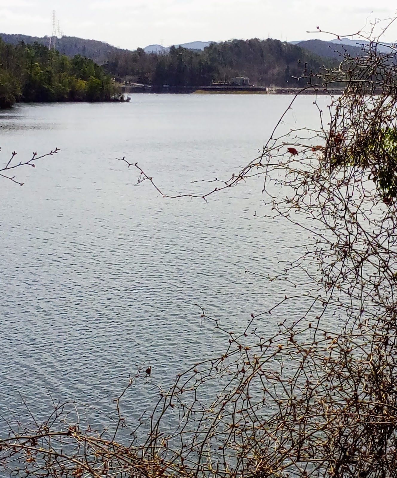
Just behind where I had been sitting earlier, was another junction that descended and emerged at this bridge. I had arrived at the head of the Kisenyama Reservoir.

The last time I passed-through here, I arrived just as this gentleman had landed a large trout. He was very proud of his catch, and was more-than-willing to pose for the camera. I was aware of a track, at the far end of the bridge, that lead to the only stream to enter the reservoir. All going well I would take the detour and check-it-out. But alas, it too was all fenced-off. This was not my day.

A few hundred meters on from the bridge I managed to catch a glimpse, and take this photo, of the dam and power plant, albeit through a wire mesh fence. This was as close I was going to get to my goal.
 Feeling dejected I moved-on. At this point my lane would turn-away from the reservoir and descend towards Uji City, and my next access point. As I was about to move off, I noticed this flight-of-steps and guide-rope which made it's way up the hill and into the forest. This looked promising, so I parked my bike and decided to check it out.
The track was well marked and well beaten, giving me the impression that this was part of a popular hiking course.

About ten minutes in, I arrived at this site overlooking the reservoir and, through the trees, my closest view of the dam. My impression was that this was an ideal location for a picnic.
 Moving deeper into the forest, I soon arrived at the summit of Mt Kisenyama, 415m (map location). As I could still catch glimpses of the reservoir, I continued on but, a little further on, the track veered-away in the opposite direction, so I decided to u-turn and return to my bike (upon arrival home, I checked the topography map and discovered there were no tracks marked on the map. With my interest in this area stirred, I have placed this on my 'must return' list).
Arriving back at my bike, I was no-sooner back on the road, and my next attempt. Passing-through the settlement of Shizukawa, my next junction, and hill-climb, was just a kilometer away - this was familiar terrain as, just over a month ago, my Wife & I came here for a walk through the Amagase Forest Park.
 After a steep ascent, I turned a bend and there it was - whala, an open gate. Maybe this was going to be my day after all. As the saying goes - 'third time lucky'.
Although the lane ascended, it wasn't too steep and I was able to cruise my way deeper into the valley and forest. A couple of trucks passed me as I made my way, no-one stopping to tell me I wasn't suppose to be here.

 Part-way up the valley I stopped at a bridge to take-in my surroundings. Looking into the forest, partly camouflaged by trees, I noticed a small shed-like construction. Upon closer inspection was this small religious icon. I have discovered these in many places during my travels, some of them in the most isolated of places, but this one takes-the-cake. Judging by the state the construction was in, this is a very-new addition to the forest.
 After 24km of cycling on a sealed surface, for the first time today my track would now become rocky and rutted, as I arrived at this collection of buildings (map location). Judging by the many heavy vehicles parked nearby, I got the impression there was a construction site in the vicinity. My GPS device showed I was closing-in on my goal, that was until the track turned in the opposite direction.

After a while the track became too hazardous to continue, as there were many obstacles in the form of large rocks, tree limbs and slips and, if that wasn't bad-enough, quite steep. I persevered for as long as I could, then decided to call it a day. I had given it my best shot, and was more than satisfied with my effort.
Maybe one day the Electricity Company will have an 'open-day', where I can check-out the facilities. And then I can say - 'I did it'.
Course details & images - https://ridewithgps.com/trips/21491298

After a hearty breakfast, I set-off, making a beeline for the Yoimachi Bridge, arriving an hour later. The bridge lies at the confluence of the Tahara and Uji Rivers.

While I was waiting for my GPS device to connect, I espied a set of concrete steps leading up to an overhanging rock. As I was in 'touring mode' I decided to check-out what lay above. I was surprised when I discovered this small religious icon nestled beneath a large rock. Of all places to site a place of worship, and dangerous as well. With vibrations from passing traffic, I was amazed that the rocks hadn't collapsed. Which was my cue to move-on.
Route-3 connects Otsu City, at the base of Lake Biwa, with Uji City, and runs parallel to the Uji/Seta River. It is flat and smooth, which it is why many road cyclists use this road to train on.


Last week, when I passed this bridge, the gate was locked, so it came as no surprise to see it in the same state. The area surrounding the entrance to the bridge is so securely fenced-off, with security cameras etc, one couldn't help but compare it to a high-security prison. My hopes were raised when a maintenance truck pulled-up and, if they were about to enter, I might be able to follow. But, alas, they just parked there. So I moved on.
I left route-3 about 3km along the road, where I commenced my first hill-climb of the day. Route-242 is a narrow & windy mountain lane that took me through the settlement of Nio and onto my next junction.

This lane was more narrower than the previous and, when I emerged from the forest, I was greeted by this sight.


Leaving my comfortable perch and re-mounting my bike, the lane re-entered the forest and I began my descent to the settlement of Ikenoo and, with fingers crossed, my second attempt at gaining entry to the reservoir & dam. Settlements like Ikenoo have a certain appeal to me.

 As I emerged from the forest, and entered Ikenoo, my attention was drawn to these two concrete lanterns, and concrete steps leading to a wooden Torii, heralding the entrance to Daishogun-jinja Shrine.
Shrines like Daishogun-jinja don't come more isolated than this, which is another attraction settlements like Ikenoo have to me - you never know what is hidden amongst the hills & forests in places like this.


I arrived at my next access point. And another locked gate. Unlike my first entrance, this wasn't as fenced-off, and I pondered the idea of squeezing-around the gate and continuing on. Although I couldn't read what the sign said, one didn't need to be an Einstein to know what it said.

As I was pondering my options, I could hear a faint humming, the sort of humming you hear when in the vicinity of an Electrical Grid Site. Peeking through the trees I espied such a site and, putting two-and-two together, what I was looking at, was the generation plant of the Kisenyamayosui Power Station.


Just behind where I had been sitting earlier, was another junction that descended and emerged at this bridge. I had arrived at the head of the Kisenyama Reservoir.

The last time I passed-through here, I arrived just as this gentleman had landed a large trout. He was very proud of his catch, and was more-than-willing to pose for the camera. I was aware of a track, at the far end of the bridge, that lead to the only stream to enter the reservoir. All going well I would take the detour and check-it-out. But alas, it too was all fenced-off. This was not my day.
A few hundred meters on from the bridge I managed to catch a glimpse, and take this photo, of the dam and power plant, albeit through a wire mesh fence. This was as close I was going to get to my goal.

The track was well marked and well beaten, giving me the impression that this was part of a popular hiking course.

About ten minutes in, I arrived at this site overlooking the reservoir and, through the trees, my closest view of the dam. My impression was that this was an ideal location for a picnic.

Arriving back at my bike, I was no-sooner back on the road, and my next attempt. Passing-through the settlement of Shizukawa, my next junction, and hill-climb, was just a kilometer away - this was familiar terrain as, just over a month ago, my Wife & I came here for a walk through the Amagase Forest Park.

Although the lane ascended, it wasn't too steep and I was able to cruise my way deeper into the valley and forest. A couple of trucks passed me as I made my way, no-one stopping to tell me I wasn't suppose to be here.

 Part-way up the valley I stopped at a bridge to take-in my surroundings. Looking into the forest, partly camouflaged by trees, I noticed a small shed-like construction. Upon closer inspection was this small religious icon. I have discovered these in many places during my travels, some of them in the most isolated of places, but this one takes-the-cake. Judging by the state the construction was in, this is a very-new addition to the forest.

After a while the track became too hazardous to continue, as there were many obstacles in the form of large rocks, tree limbs and slips and, if that wasn't bad-enough, quite steep. I persevered for as long as I could, then decided to call it a day. I had given it my best shot, and was more than satisfied with my effort.
Maybe one day the Electricity Company will have an 'open-day', where I can check-out the facilities. And then I can say - 'I did it'.
Until next time,
Sayonara.


