In September I signed-up with 'Strava' so as to take advantage of their G.P.S. tracking and the opportunity to share my rides with other like-minded cyclists and outdoorholics and, if possible, discover new routes that may be of interest to me.
 |
| Torii, entrance to Atago-jinja Shrine. |
Towards the base of the hill, on the Yamashina side, is this unobtrusive concrete Torii. After my third-or-fourth trip over the hill, my curiosity got the better of me, and I decided that this site needed checking-out. And I am very pleased I did take the time to do just that, as this was to become the beginning of something big.
 Locking my bike to a fence, I proceeded on foot and, about a hundred meters up an incline, was a derelict collection of buildings and religious icons that added an eerie feeling to the site. This was Atago-jinja Shrine. Map location - https://goo.gl/maps/FcfoRB4Led12

On a cold and miserable morning, with remnants of the previous evenings snow falling from the overhead canopy, I headed to the Higashiyama side to check if-and-where the track emerged. Upon arrival at the track-head I discovered the 'Kyoto Trail' - an 80km track that circumnavigates the city - passed through the area. This was getting better-and-better, and I was beginning to envisage a great ride in the making. Course map & details - https://www.strava.com/activities/2105734754
The big day arrived. I had done all my research and, barring any mistakes and other unforced errors, set-out from home in ideal conditions - clear, calm & warm. I made a beeline for Atago-jinja, taking another couple of photos, and headed for the track junction. Upon arrival I was greeted by a young American who, as it turned-out, was a local tour guide out with a client. As he knew the area like the back of his hand, he gave me some very invaluable advice. Which I was most grateful for. As they were heading in the same direction, I tagged-along behind and, in doing so, missed my turn-off, and ended up at the precincts of Fushimi-Inari.

Exiting the Sennyu-ji complex, I soon found myself crossing the Daigo-Michi Road and into a forest where remnants of last August storm were still being cleared; the 'Kyoto Trail' is maintained by volunteers and, as it is a popular course, work gangs would have been out at the first opportunity to clear any fallen trees, as can be seen in the images on the left.
Like the previous section, there was very little opportunity to ride my bike plus, not knowing where & when I would encounter a hiker, the risk of hitting someone was high. This being a weekend day.

The track made a sudden descent and emerged onto the Higashiyama Driveway. A bridge took me over route-1, a main arterial road in-and-out of Kyoto City, and on up to the Higashiyama Mount Peak Park and Observatory (map location). The 90-degree view from the observatory allowed one to see as far as Yamazaki & Yawata to my left, south-west, and Kurama to my right, north, with great views of the city front & below.
Backtracking a short distance, onto the Driveway, I soon arrived at Sanjo Dori, another busy arterial road.
From here I cycled to Kawabata-dori, where I soon joined the Kamogawa River cycleway and on home. Course map & details - https://www.strava.com/activities/2118245057 Upon arrival home I was buzzing with joy, but I felt I needed to return as there something - another track, religious site - that I needed to explore. And a week later, I did just that.

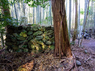
As I commenced, I noticed how well the track was clearly marked, some of which were in the form red tape, with a black arrow pointing in the direction I was heading. This indicated that this was a course that, I surmised, returned to the junction I had just left. Before long I reached another junction, with a track branching-off to my left. Curious, I took it. It came to a sudden end when I arrived at a monument - above image - before returning to my original course. A little further on, another junction. Thankfully a lone hiker was here who translated where each track led. Apart from the one I had arrived on, one of the other tracks let to the summit of ((Mt)Inariyama, the other down to Yamashina. As I didn't want to repeat my encounter with Fushimi-Inari the week before, I decided on Yamashina.
As I had no plan from this point, I decided to head back up the road, and link-up with the 'Kyoto Trail'. And from there through to the junction of the Higashiyama Driveway. This bench, at the plateau of this section, provided an ideal location for a break and a bite-to-eat.
 |
| Map Location. |
I had heard about this tunnel, and was interested in checking it out for myself. It turned out to be a pedestrian/cycling tunnel that ran parallel to route-1.
As I now knew where I was, it was time to call it a day, and head for home. I took route-1 towards Yamashina, where I connected with a cycleway alongside a stream. From there to Rokujizo, Yawata and home.
Course map & details - https://www.strava.com/activities/2135765242


No comments:
Post a Comment