My latest Post.

This view,this beauty
A tear unbidden
Creeps into my eye.

My stay is short
But I shall return to this place
If only my life is long enough.

Such beauty
Gazing upon it
I hope my years are many.

Bokusui Wakayama.

Wednesday, September 7, 2016

Exploring Tayama.

    It was a map of cycling courses through the tea-growing district of southern Kyoto Prefecture, that drew my attention to the settlement of Tayama. It was an area that I had passed-through, on one of my many cycling tours but, on this occasion, I decided to explore the settlement more closely. The map showed a couple of shrines - one hidden atop a hill amongst the many tea plantations and the other on another hill overlooking the town - and a cafe located in a disused school.
Map Location.
   My plan was to cycle to the Kasagi-ohashi Bridge, about 32km from home, set-up my cameras, have a banana, washed-down with some water, then head-off along a track that followed the Kizu River. The track is part of the 'Tokaido Road' which was created about four hundred years ago for travellers who migrated between Edo (modern day Tokyo) and Naniwa (modern day Osaka).
   Along the first 5-kilometers of track I was to experience an assortment of Shinto & Buddhist Stone Markers. These are always a favorite of mine as one can come-across them in some of the most isolated of places. 


   On my left is the Kizugawa River. This river has a very large catchment basin and, whenever there has been rain, especially a downpour, this river very-quickly becomes a raging torrent. Evidence of a recent typhoon were still lying several meters up the river-bank and bridges were being cleared of debris.
Map Location.
   My next stop was at the settlement of Asukaji and the Amaterasumikado-jinja Shrine. Tucked-away amongst the trees, this complex is an ideal place to take-a-break and soak in the serenity of your surroundings. There has been a shrine on this site for over 1,200-years.
   As I passed through Asukaji I was soon to be reminded that it was 'that' time of year again - rice harvesting. It just seems like yesterday that the fields were being prepared for planting. How time flies.
                                                                                                                   In places the path becomes narrow and overgrown and, all around me, is evidence of a typhoon that had just passed over a few days prior to my visit. I had one narrow escape, as can be seen on the video, of where I nearly cycled into a fallen tree. 

   Immediately below me, on my left, is the Kizugawa River. I am always mindful, when cycling along tracks such as this, to be aware of others, especially hikers. Medical treatment in Japan is very expensive and the cost of paying someones hospital bills would leave a very large hole in my bank account. 


   I soon pass through the settlement of Minamiokawara and my first junction of the day. About 4-kilometers along route-82 the Tokaido Road and I part company, at . . . .
Map Location.
 . . . . the Takayama Dam. It's difficult to imagine, when looking at this construction, what the view was 400-years ago. There was probably just a stream the migrants had to contend with back then.
Map Location.


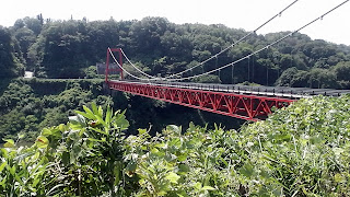
   Two kilometers further up-the-road I arrive at this impressive bridge that spans Lake Tsukigase. On the far side is my destination - Tayama. But, before I cross, I take a moment to soak-in my surroundings. If I only had a kayak. 


   Tayama is about 1-kilometer from the other side of the bridge, which I pass through in search of Gongen-jinja Shrine. Once there I plan to have a break and a bite-to-eat. But I have to find it first. I am aware, after studying 'Google Maps', that there are many lanes/paths criss-crossing the hills and the shrine is located in there somewhere. This is where a local farmer comes to my assistance. With the few words of English he knows, he is able to give me directions that, if I have paid attention, should get me to my destination. I head-off up the first lane that emerges into a tea plantation. Just as I arrive there, my farmer friend appears in his small truck, after having taken another lane, to give me further directions. I couldn't express enough how grateful I was for his assistance. 
   As you can see in the satellite-image, Gongen-jinja is very isolated, to say the least and, upon arrival, you can't help but get the impression it has seen better days. But the surrounding views and the serenity makes one appreciate the beauty of the countryside.


   I am particularly intrigued with this Chozuya. As there was no visible water system, I assume someone brings some in a pail or rainwater is the other option.With all this beauty and serenity surrounding me, what better location to break for lunch.
   My return to the settlement, and my next shrine in the area, is via an alternative lane - quite possibly the one my farmer friend used earlier - but, before entering Suwa-jinja Shrine, I stop to admire the stone markers at the entrance.
                                                                                                                                                                I am impressed with this Sekibutsu as it hasn't been carved into solid rock, but what looks like a slab of rock. The L-shaped slab wouldn't be more than 3-cm thick. 

   Suwa-jinja is very imposing, not just for it's size and grandeur, but how it overlooks the settlement of Tayama. Wherever one stands in the town, the shrine is there for all to see.
                                                                                                                                                                Just off the main street of Tayama, is this disused elementary school that has been taken-over by several craft shops and this . . . .


. . . . quaint cafe. Walking into Cafe Nekopan was like going back 50-years, to when I attended Primary School at Dunsandel. It just seems like it was yesterday. The cafe has a very-appetizing menu and I highly recommend to anyone who is likely to be in the area.


   After a glass of ice-tea, courtesy of the owner, I move on. By this point I have clocked-up 50-kilometers and am still a long way from home. But, as I still have the energy, I decide to take another route back to Kasagi and more sightseeing.
Map Location.
   Like this bridge and settlement at the head of Lake Tsukigase. From this point to Kasagi, 14-kilometers away, I'm going to experience my first hill climbs of the day and I need to pace myself because, after reaching Kasagi, I still have 30-kilometers before reaching home. 
    An hour, and three hill-climbs later, I arrive at the town of Yagyu. The town was made famous for housing one of the oldest schools of swordsmanship in Japan - Yagyu Shinkage-ryu.
   But it's this Sekibutsu that I am keen to revisit, as-well-as have a bite to eat and take on water. This stone marker is very significant to those trying to conceive. What you do, is come here, along with a tray of Tofu, place the tray at the base of the icon, pray, then go away and hope for the best.
   From here to Kasagi it's downhill all the way. I arrive at the bridge that I departed from four-and-a-half hours and 37-kilometers earlier and am praying I have a tail wind home. The trip along route-163 - a busy highway at the best of times - can be hell if there is a head wind. But the gods are on my side and I am helped all the way home.

                                                            So, until next time,

                                                                     Sayonara.  


Course details and map - https://ridewithgps.com/trips/10851435

Video - https://www.youtube.com/watch?v=9TWME855DFc 


Sunday, August 7, 2016

The Daibutsu Railway.

 
    The Daibutsu Railway has been nicknamed 'The Lost Daibutsu Railway'. With a short lifetime and little documentation, much remains a mystery. However, today, more than a century later, tunnels, abutments and other remnants still stand and provide us with clues of how the ephemeral railway looked.

   In April 1898, the Kansai Railway Co. opened an 8km branch connecting the town of Kamo to a station beside the Daibutsu (Great Buddha) of Todai-ji Temple, in Nara Park (aptly named Daibutsu Station). The area flourished as a popular sightseeing spot. Then, a year later, in May 1899, the line was extended a further 2km to Nara Station.

   In August 1907, a new and level route going from Kamo to Nara, via Kizu, opened. Troubled by steep slopes , the Daibutsu Railway services halted and, in November of that year, the line was closed after just 9-years in service.

   The new line, which was incorporated into the already existing 'Kansai Main Line', is nicknamed the 'Yamatoji Line', and still operates to this day, more than 100-years after opening.
                                                                                                                                                                An artists impression of  'The Inazuma SL' (Cardinal Train) as it passes over one of several abutments between Kamo and Nara Stations.

                                                                                                                                                                                                                                                                                                                      The thoughtful people down at the J.R. Promotions Department, have created this map of the course that, supposedly, follows the route the Daibutsu Railway took.

    I have hiked/cycled parts of this course over the years, and am familiar with some of the sites. So, all decked-out with what I need for this trip - cameras, food, drink, appropriate clothing e.t.c. - I shall head-out from Kamo Station to walk to Nara in search of the Daibutsu Railway. 
J.R. Kamo Station.
   I decided to commence my journey at Kamo Station so as to follow the numerical instructions on the map. The original station was opened in November 1897 as the terminus of the Daibutsu Line. When the line closed in 1907 it became the termini of the Yamatoji and Kansai Lines.
Lamp House.
   A few meters down from the station is the first relic of the old railway. This is a Lamp House, constructed of brick with a gable roof, and has been standing here since the foundations of the station were laid. Today, from what I saw, the building serves no purpose, but to remind us of a bygone era.


C 57 Steam Locomotive.
    My next stop was this static display. Nicknamed 'Kifujin' (The Dame), this steam locomotive was built in 1937 and once ran on the 'Kansai Main Line'. In the above image, an A 221 Electric Multiple Unit has just left Kamo bound for Osaka. Steam locomotives have a special place in my heart. There is something about these beasts that impress me.
   It wasn't long before I was bidding farewell to the town of Kamo, and entering the lush green rice-fields that make Japan so picturesque at this time of year. This is my kinda' environment and I am in my element whenever I enter, either on foot or on two-wheels, areas such as this.
   Not far from where I am standing,  camouflaged by the out-of-control vines in the distance, is the first of six abutment relics.
Kanonji Abutments.
   The Kanonji Abutment was constructed of graphite ashlar and features two foundation stones on top. From the Kamo Station, to this point, the Kansai and Daibutsu Lines ran parallel, a distance of 2km and, from this point they part company.
   If you are here at the right moment, like I was, you should be able to experience the A 221 E.M.U. passing by. Looking in the distance, under the bridge, is where I took the previous photo. 
                                                                                                                 My next abutment is just over a kilometer away but, before I reach it, I have to traverse through bush that suddenly becomes more dense as I progress through it. But that is not my only concern. I am suddenly engulfed by swarms of insects that take great delight in exploring every nook-and-cranny of my body. The infestation doesn't last for long, thank god. Midway through I happen-across this small Shinto Shrine. Always a source of pleasure for me - one experiences these in some of the most isolated of places, along with Buddhist icons - and an opportunity to stop and offer a prayer (on this occasion I didn't thanks to my insect friends).
Kaseyama Abutments.
   Emerging from the bush I soon rejoin a sealed lane and the Kaseyama Abutments. Again, constructed of graphite, the blocks appear dark and dirty. This is caused by the moisture being emitted from the waterway that runs through the tunnel. At night the stones glisten elegantly. If you take note of the notice-board in the right of the image,every point-of-interest stop along the way has a board giving details of the site in Japanese, English and Korean. Plus a map of your location and course. I give the organizers 10-out-of-10 for this.

Kajigatani Tunnel.
      To access  the next site requires some navigational skills. But the task is made easy thanks to great signage. But, in saying that, you still have to have a keen eye, thanks to our friend, the overgrown vines.                                                                                                                 

   With no copestones, or other decorative features, the Kajigatani Tunnel is simpler than the other structures. The front bricks are in English Bond, and the arch are in Stretchers Bond. The tunnel was used as a passageway and an aqueduct.


Akabashi.
                                                                        Akabashi literally translates to  'The Red Bridge' - Aka = Red,    Bashi = Bridge. Again, this structure is constructed with English Bond,  embellished with capstones and paved with granite. Granite quoins have been stacked on alternating sides so as to reinforce the structure.

   The time has just turned 12pm, and I have already been on the track 2-hours in sweltering heat and am looking for a place, in the shade, where I can stop for a break.
                                                                               And, just like 'that', my prayers have been answered. And with a toilet too. I never thought an ice-coffee and current buns could be so appreciated. It had been just over 5-hours since I last took-in fluid and food.
   Sitting at my bench I look-around at my surroundings and admire the view. In just over a kilometer from where I am, my surroundings will change dramatically as I am about to be engulfed in the residential surroundings of Nara City.
The Vestige of Isekigawa Bridge.
   Before this became an ordinary road and vehicular intersection, the Daibutsu Line ran through here (I emerged down the road in the center of the image) and, because of the height difference, the railway had to construct an embankment, bridge abutments and iron bridge.
  
Map Location.
 
   No evidence of the bridge, or it's abutments, are here to remind us of that era so long ago destroyed. I was able to track-down the above images of the construction of the Isakigawa Bridge.
   The narrow lanes and dirt tracks of the past 3-hours have now been replaced by the asphalt sealed footpaths, pedestrian crossings and controlled intersections. What a shock. If it hadn't been for my map, I would have missed the next site.
Matsutanigawa Tunnel.
   Descending a flight of steps, I arrive at someones vegetable garden and spy a concrete path heading in the direction of another noticeboard. The granite voussoir, in the arch of this tunnel, are stacked on alternating sides, a building technique known as - 'Sangizumi'. The dark bricks were made with high heat and, along with bricks made of alternating shades, are a distinctive feature of the Matsutanigawa Tunnel.
Sikagawa Tunnel.
 The Sikagawa Tunnel, and the last of the abutments and, unfortunately, inaccessible to the public - I think it being on private land may be the reason why. The tunnel still retains it's original features. It is a narrow tunnel and was constructed for agricultural purposes, so a stream could pass under to allow irrigation of the fields on the other side of the tracks.
The Vestige of Kurogamiyama Tunnel.


   You wouldn't believe it, looking at this image, that, until 1966, there was a tunnel here. This was the site of the only tunnel on the Daibutsu Railway. Today it's route-44. Difficult to imagine what this scene looked like back when the service was still in operation. 

   From here I make my way down route-44, past the Nara Television studios, the Nara Youth Hostel, many other shops and eateries, to an indistinct intersection, and my next stop . . . .
The Commemorative Park of the Daibutsu Railway.
   . . . .  the site of the Daibutsu Station. Thanks to the collaboration between the Nara Municipal Office and Local Residents, in 1992 this park was created to commemorate what was once a great era in travel. And sadly missed.
   Thanks to the efforts, and talented computer skills, someone has kindly created this image of what the Daibutsu Station looked like. Doesn't the Inazuma SL look resplendent? It brings a tear to my eye. 
The Sahogawa River Bridge.
                                                                                Directly in front of the park is the Sahogawa Bridge, and the entrance to an area of Nara known as 'Funahashi'. This section of the line wasn't opened until a year after the first section was commissioned - May 1899.
    As I cross the bridge I look upstream of the Saho River, and espy these three deer grazing on the lush green grass on the banks of the river. The deer, which are domesticated, are a popular feature of Nara, especially in the area engulfing the Park. Which is why I am surprised to see them so far from home.
    As I make my way down Funahashi I pass this well restored and preserved establishment. It is becoming common here in Japan, especially in the famous old cities like Nara and Kyoto, to restore these houses so as to save them from demolition to be replaced by modern structures. At this point I am getting a gut-feeling that my journey is about to reach it's climax. And, after another couple of intersections . . . .
J.R. Nara Station.
. . . . I arrive at my goal, or the end-of-the-line (excuse the pun) - the J.R. Nara Station. Over the past 4.5-hours, I have walked 12-kilometers and have seen and experienced some great scenery. It's a sad moment but full of memories of an era long passed. For me, it reminded me of my childhood and growing-up in a rural town and witnessing the  steam locomotives as they passed-through where I lived. And of travelling on them and the sound they made, and the power. I so wish railways like this weren't closed but were kept open for all to experience and appreciate.

                                                 So, until next time, Sayonara. 

Course details and images - https://ridewithgps.com/trips/10345007

Video - https://www.youtube.com/watch?v=odoRA9aLics