My latest Post.

This view,this beauty
A tear unbidden
Creeps into my eye.

My stay is short
But I shall return to this place
If only my life is long enough.

Such beauty
Gazing upon it
I hope my years are many.

Bokusui Wakayama.
Showing posts with label Hiking.. Show all posts

Sunday, April 22, 2018

Ushiozanhougon Temple and Beyond - Rokujozo Loop.


   When I was planning my previous excursion in this series (Oiwake Station to Rokujizo Station), my intention was to hike through to (Mt)Daigoyama, and descend via the Upper Daigoji Temple. But, when I reached the junction of route-782 and the Daigoyama track, I decided to forgo the summit & temple and make a beeline for Rokujizo Station, with the hope I could return and continue my hike through at a later date.


   So, when on a cycling excursion into the area, I discovered this noticeboard with a map of hiking trails in the area. The map wasn't very descriptive, but it was extensive. But it still didn't give me the confidence that I could link-up with Daigoyama and route-782. The only way I could know for sure, was to attempt the link from the other end of the mountain range and, in early April, I did just that. With success.


   An hour after setting-off from Rokujizo Station, I arrived at the completion point of my last hike in this series, and grateful it wasn't hot; the hill-climb was steep and very rugged in places. This small shed, with a Setsumatsusha on the inside, and religious icons on the outside, heralded my arrival.


   After a brief break, while I caught my breath, I was keen to be on my way. After a short climb, the track leveled out and, before I knew it, I had arrived at Kami-Daigo, or the upper part of the Daigo-ji complex. This is an enormous complex and requires the best part of a day to explore the many temples, shrines and monuments that adorn the area.


    As I had already spent the best part of a day exploring the site - about 10-years ago, if my memory serves me well - I took a few images and continued on. As it was just over a week ago when I passed-through here, I needed to remind myself that any interesting sights I experienced then, were now in reverse order, and I also needed to be aware of the many junctions I would encounter.


   About 15-minutes on from Kami-Daigo I encountered this set of steps, as I was doing good time, and my curiosity got the better of me, I decided to check-it-out.


   With the many tombstones that were scattered-about, I would hazard-a-guess I had arrived at a cemetery. As I have respect for privacy, I didn't encroach by taking any photos, but I couldn't help but admire this monument, especially with the colorful Spring foliage that was abound.

   Back to the track, and on my way, I was soon to arrive at something that has left me scratching-my-head. At the next junction I observed this tunnel, presumably to allow the stream water to flow through. The bank looked man-made. What was the purpose for this construction? It beats me. Maybe someone with knowledge of this area can shed some light on it. 

   Although it was still quite early, it was just after 9:30am, it had been more than four hours since I had had breakfast, so I was looking for a spot to take-a-break and have a bite-to-eat. And I knew the ideal location - 


    There is nothing like a good view when relaxing over lunch. And this has to be one of the best locations for just that. My lunch-spot was a crag of rocks that just seemed to pop-out of nowhere. In the center of my view, sitting atop a hill, was Fushimi-Momoyama Castle, with the sprawling suburbs of Kyoto City.


    Lunch over and done with, I headed-off to my next destination - (Mt)Hinoyama 373m. A junction offered me the alternative to bypass the summit, or a direct route. Needless-to-say what option I took. There was no view to be had, but I was impressed with the pyramid of rocks and the many signs detailing the mountains name and height, five in all.
   Leaving the summit I was now on the look-out for a junction that I didn't want to miss. As I mentioned earlier, I was doing this hike in reverse order from last week. The reasons will soon become obvious.

   From the junction I would leave the main track and descend, then re-ascend via another track and return to this point. 300m on from Hinoyama, I arrived and commenced my detour.


                                                                                                                                                                                                                                       A few minutes into my descent I came-across this site. Although the building looked unobtrusive, it was the sight of all the religious icons, hundreds of them, that surrounded the complex, that was of interest to me. This discovery confirms my suspicions that the area is part of a pilgrimage.
    
   My next junction was unexpected so, being left-handed, I took the left track. A few hundred meters further on, and another site that has left me scratching my head. Just down a bank, sheltered by an enormous rock, was this derelict building. Upon closer inspection this, at one stage, may have been a shrine, and the rock had something to do with it. Inside there was evidence of Shinto decorations, along with other discarded rubbish, although a quick tour around the rock unearthed nothing out-of-the-ordinary. One day I may be in the right place at the right time, and meet that someone with local knowledge. 


   My next encounter was this Buddhist statue, and again another episode of interest. Why here, in the middle of nowhere? There was nothing else about. By this time I was really hoping I would meet that someone.
   In the coming minutes, the answer to that question might be found, when I emerged onto a sealed lane, with a few houses camouflaged by the overhanging forest. Maybe there was a cemetery close by. The sealed lane only lasted a few meters before I re-entered the forest and onto my next point-of-interest.     
                                                                                                                      In the early 13th century, a Japanese author, poet & essayist, by the name of Kamo no Chomei, lived a life of a recluse on the site where these monuments now stand. He lived in a small hut, sometimes composing poetry, for the best part of five years, before his death in 1216. Kamo no Chomei was raised in the courts of Kyoto but, when passed over for promotion within the Shinto shrine associated with his family, he turned his back on society, took Buddhist vows, and became a hermit. I can't help wondering if he too roamed these hills.


   Leaving Kamo no Chomei, I moved-on and, before long, I had reconnected with my earlier track, passing the religious icons before arriving back at the junction. And,I have to say, I was quite pleased with myself.
   From here, it was off to my next destination, (Mt)Tenkaho. As I made my way I passed another junction. This was the descent back down to civilization and, from memory, I was in for a rough time. The previous week, when I ascended to this point, the track & track markings were almost non-existent. But, first-things-first.


    (Mt) Tenkaho 348m was interesting. Interesting in that it looks like it has been made-into a picnic site. The area, immediately surrounding the summit, has been cleared, and a table, of sorts, has been constructed. It must be a popular destination. On this day, I had the summit all to myself - actually, the only other souls I encountered all day, was at Kami-Daigo. So, with the sun streaming-through the trees, I used the serenity to take another meal break, and review my day. The conclusion I came to, was that the track was well maintained but, unlike the area surrounding Ushiozanhougon Temple, there was very little signage. With a large network of tracks, it would have been helpful to know where other tracks led to. Which is why I plan to return and check them out. Another mug of cafe au lait, and another Onigiri (rice ball), I was now psyched-out for my descent.


   The trees in the area around the junction, and the first few meters of the descent, have been painted with red & yellow bands. Then it's guesswork from there on. On my ascent I followed a stream, so I decided to do the same now. In parts the ground was very loose rocks, and steep, so care was needed. I zig-zagged for some of the way, relying on young trees to hold onto and, in others, I had the luxury to stop and admire my surroundings -    
With sights like this, I feel grateful I still have one good eye to admire & appreciate the beauty that surrounds me.
   In the coming meters I would hear the familiar sound of running water, albeit a trickle. But that trickle would soon turn into a stream. The only problem was, that over the years this stream has gouged-out the ground, which required more care than my earlier experience. I lost count how many times I hopped from one side to the other, and how many near-misses I had, as I scrambling-up the opposite bank.


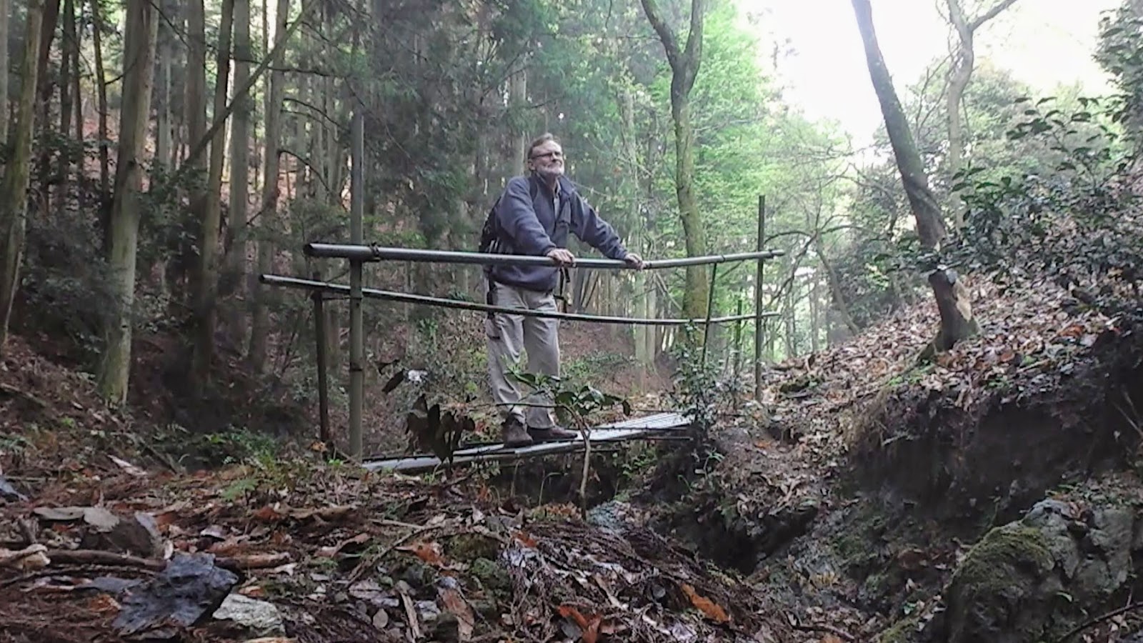
   But then, there in the distance, I saw it. A footbridge. The first of four I would cross before emerging back into civilization. These bridges are constructed of steel piping and, anyone over 150kg, would have to find an alternative crossing - thank god I wasn't Ichinojo, he weighs-in at 215kg. From this point the track was more defined and, once emerging from the forest, I arrived at my goal, the Yamashina Driving School. Where I discretely made my way to the entrance, in case I was apprehended for trespassing.


   I couldn't resist the urge to include these two images. They were taken on my first venture into this area, a week or so before this trip. The evening before it had rained, and the valley was very misty. I remember having to remove my glasses several times, as they kept on fogging-up. Makes one appreciate the beauty that surrounds us.


   As always, it has been a pleasure sharing this with you, and thank-you for reading this post.


Sayonara.

   Course details and images - https://ridewithgps.com/routes/27299553

Thursday, September 21, 2017

The [S]Torii Still Contunies.


   If you read my post - 'Rural Nara Circuit' - you may have been impressed with my discovery of this metal Torii, partly obscured by trees and undergrowth, along route- 186 in the settlement of Nakahatacho, rural Nara.
   A Torii is suppose to signify a gate, or entrance to a Shinto Shrine. So, when I stumbled-across this find, I was keen to see if/where the shrine was. Nothing. This bugged-me and I needed to know more.


     So, 5-days after that visit, I returned on my 'The [S]Torii Continues' trip to see if more lies in the bush surrounding the Torii and, hopefully set my obsession to rest.
   Upon my arrival I forwarded a copy of this image - the tablet hanging from the Gakuzuka, or supporting strut - to a friend, and a reply came back almost immediately. The inscription reads, "Hachidai Ryuou Oogami", and is about the God who shaped the Dragon with Eight Bodies and is said to be the God of Water.


   As I was looking about, I discovered what looked like a track and, as I was only wearing my cycling shoes, decided to end my search there, with the intention of returning and seeing where the track leads.


   Today I arrived at the Torii on two feet, after a 90-minute bus & train ride to get to Yadawaracho, and took my time, as I strolled through the aftermath of the rice-growing season. On my first visit, 10-days prior, this looked so very different.

     Just as I was about to emerge onto route-186, I spotted this track and wondered where it lead to. A quick check of my internet map revealed it joined the track I was about to take. I would keep a lookout for this junction as my day progressed. 


   Once I set my G.P.S. App' into recording mode, I didn't waste any time getting underway. As I made my way down the hill I soon arrived at a stream, that I noticed how it's banks had been lined with rocks. I would experience many situations like this throughout the course of the day.

   I soon arrived at the spot where I ended my walk five days earlier. On a couple of trees in my vicinity, I espied some red tape and what looked like a track. As I was still close to the road, I felt this may return me to where I started and so moved-on. A little further on and, another rock-lined section of the stream, and what looked like the remains of a bridge.


   As I was making my way along the stream, crossing it from time-to-time, I couldn't help but get the feeling I wasn't the only life-form that had recently passed through this way. I encountered many wild deer tracks running alongside the stream so, if I kept my noise-level to a minimum, I might be lucky in seeing one-or-two. 


   At times my track required some risky maneuvering - rock-hopping across the stream, clambering up the bank, bush-bashing - when, suddenly, I arrived at this junction. I decided to leave my planned route for a few minutes and take the other track when I suddenly realized this was the track I saw earlier. This was later confirmed when I checked my internet map.


   Up to this point I had come-across many forms of fungi, most of them on broken branches and tree-stumps. Some of them quite beautiful and in an assortment of colors.


   My next stop was at this bridge. Checking my map, to see where the track lead to, and liking what I saw, I decided on this occasion I would detour from my planned course. But, fifty meters on, I met a wall of overgrown scrub, vines and bamboo and soon u-turned back and continued on my way.

   
    The track, at this point, was becoming more defined and, as can be seen in this image on the right, just a beautiful. I was beginning to get the feeling I was closing-in on civilization and the conclusion of my days hike. So, while here, make-the-most-of-it and slow the pace a notch, or two. It had been just over an hour since starting-out.

       
   I was about to encounter my third, and final, rock-lined section of stream and a site that gave me the feeling there had once been a settlement here. The risky-looking bridge led to an area, about the size of a rugby field, that looked like it had been excavated many moons ago and all that remained were a scattering of trees. I took the path down to take a closer look. There was no evidence of any buildings, or pits, or water troughs. Strange.


     Gradually my course had progressed from a dirt track, to a concrete path and then finally a sealed lane. I turned a corner and, there in front of me, was the settlement of Kitatsubaocho. And the end of this section of my days hiking. After arriving at the junction, and switching-off my G.P.S. App', I headed up the road to Shoryaku-ji Temple, and . . . .


. . . . lunch. My feet were killing-me, and I needed to take-a-break, rest-up and take on sustenance. I discovered, when removing my boots, I had forgotten to insert the inner-soles. I thought there was something I had forgotten.

      From here I made my way through another forest, passing this Tumulus Pond, and eventually joined the Yamanobenomichi Path, one of the oldest paths in Japan, that would take me onto . . . . 

. . . . Nara Park. And another mug-of-coffee and sultana buns, before my final stretch to Nara station, and my train home. Although my curiosity over the Torii wasn't satisfied ( I hope that will happen this weekend, when my wife and spend the day at Yadawaracho), it was still a great days hiking.


So, until next time - 

               Sayonara. 


    Course details - https://ridewithgps.com/trips/17825270