My latest Post.

This view,this beauty
A tear unbidden
Creeps into my eye.

My stay is short
But I shall return to this place
If only my life is long enough.

Such beauty
Gazing upon it
I hope my years are many.

Bokusui Wakayama.

Monday, April 1, 2019

Nishigamo, Kyoto City.


   In the western suburbs of Kyoto City, is an area known as Nishigmo. There isn't much in this area that attracts the tourists, unlike other parts of the city, but, once a year, on the evening of August 16th, all eyes are turned to (Mt)Funayama, and what is known as 'Gozan no Okuribi'. This is a festival where five giant bonfires are lit on mountains surrounding the city. As one who has experienced this event, it is a sight-to-behold.

   This area was brought to my attention by a fellow outdoorholic, who I am connected to through our 'Strava' pages. Looking at a particular trip he had done, I became interested in what lay within the hills of Nishigamo. And so I decided to do some exploring of my own.


 'Exploring the Hills of Nishigamo'

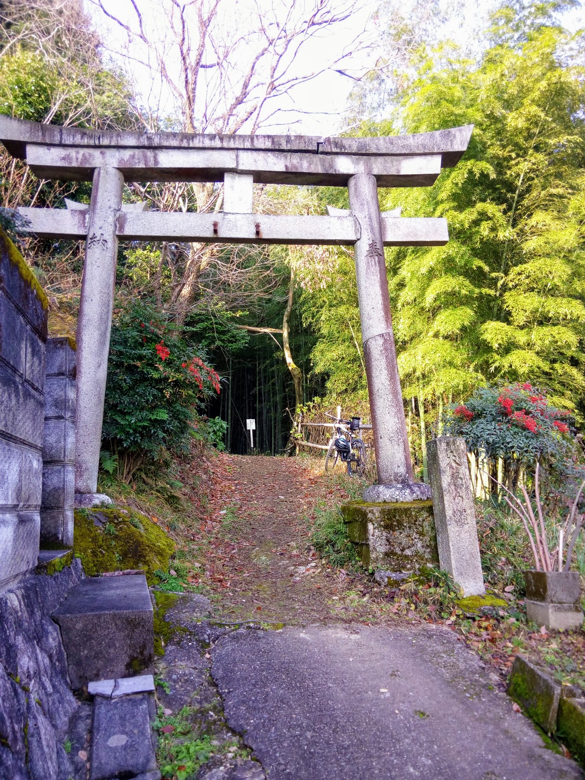
   This was to be my first venture into the area. I had the choice of two tracks, both converging within a kilometer of the road, so I decided to take one through to the Himuro-michi Road, then u-turn and return via the second. I needed to be prepared to abort my trip at any stage, as I was conscience that there still may be remnants of 'Typhoon Jebi' obstructing my way. I had no problem in finding the track, and, upon arrival, I set-off. The first few-hundred meters the surface was concreted, which was nice, but then it turned into a muddy track, which one would expect of this type of terrain. With Kyoto City, and it's environs at my back, I was quite overwhelmed with how quickly my surroundings had changed. And peaceful too.


   About one-kilometer in, and I arrived at this junction. This was my second track and, all going well, I would return here in the not too distant future. But,before I moved-on, I did a quick check that this was where I thought I was. The reason for that, is that the track from this point changed dramatically.


   Gone was the soft undergrowth of fallen leaves & pine-needles, and wide open track. From this point on it would be rocky, rutted-out, tree-weaving and, for most parts, I had to walk and, at times, carry my bike. But I didn't mind. The surrounding scenery was worth the inconvenience. 


     I was surprised how little evidence there was of the storm of last August. I would have expected more obstructions. Not that I was complaining. In some sections I was able to mount my bike and cruise-along at a leisurely pace plus, as I was doing good time, stop and take a couple of photos. I noticed, as I made my way, several tracks branching-off the one I was taking. Taking note of these, I would research their destination upon returning home, in case there was the possibility of me returning here.


Map location.
                                                                                                                                                                          Then suddenly I emerged out into open space, and familiar territory. I had arrived at the junction with the Himuro-michi Road. Familiar, because I have traversed this road several times of the years as I hiked the 'Kyoto Trail'; an 80km trail that partly circumnavigates Kyoto City. I am feeling very exhilarated and, during a short break, I decide to change my plans and head for the settlement of Himuro, and link with the Kyoto Trail.


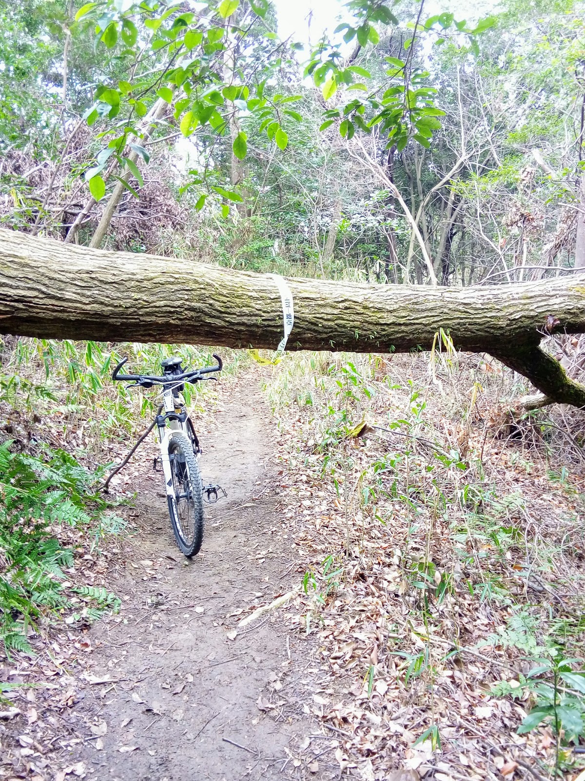
   My memories of this track are of a steep, narrow & windy descent and I prepare myself to the inevitability of having to carry my bike for the most part. But, what I did forget to take-into account, was the possibility of storm damage still in evidence. In some places the track took a detour, where I had to lug my bike up a hill, scramble under-&-over  fallen trees, before returning to the course proper.
Map location.

   There were some moments when my surroundings were very beautiful, like this bridge. It was while preparing to take this photo a group of elderly-women hikers appeared, and their surprise to seeing a lone cyclists in such an isolated location, brought-on rounds of giggles and chattering.


   For this 3km section of track, I think I only managed to cycle a combined distance of 100-meters, if that. So, when I emerged at route-61 (map location), I was somewhat relieved that I was able to re-mount my bike and move on at a better pace. Like my arrival at the junction with the Himuro-michi Road, I was still feeling great. So I made another change. I would take routes -38 & 40 through the settlement of Shizuhara to Ohara and from there back into Kyoto City and home.
   Six-and-a-half hours, and 92km later, I arrived home, somewhat saddened that the day had come to an end. It had been a awesome bike-ride and, as a 65-year old, I was very proud of myself. But I wasn't finished with the hills of Nishigama. That second track, the one I didn't explore, played on my mind over the following days, so I made the decision to return, and, while doing so, check-out another track in the area. Again, courtesy of my 'Strava' connection. But that's another post.

Course details & map - https://www.strava.com/activities/2212101579


So, until next time - 

Sayonara.  


Thursday, March 7, 2019

Checking-out the hills overlooking Yamashina.


                                                                                                                                                                          I have spent many hours cycling through this area over the years, but it was another post on my 'Strava' page that alerted me to the possibility of some off-road cycling/hiking tracks. Checking this map, and other maps of the area, I came to the conclusion that there was quite a network of tracks, entering & exiting at different locations within this part of Kyoto City.


   Access to the area known as Yamanaka, is via the Yamanaka-goe Road, or route-30. This road, that connects the cities of Kyoto and Otsu, is narrow and quite windy, and care is needed when traversing. At the plateau is the entrance of the 'Hieizan Driveway'. 
   There are also several distractions, especially on the Kyoto side, like the . . . .


Nitten-ji Temple & Shrine (map location). As car-parking is non-existent, being on a bike/foot is an advantage.


   Other distractions include religious icons.


   My plan was to do a reconnaissance ride into the area, and connect with the track my Strava connection had taken but, unlike his trip, I would descend. My research revealed that some of the tracks lead to (Mt)Daimonjiyama, a mountain overlooking Kyoto City and made famous for the 'Gozan-no Okuribi' Festival.


   Arriving at the plateau of the Yamanaka-goe, I then branched off and made my way through the settlement to where my off-road adventure would, I hope, commence. The settlement is constructed in a Grid Plan  layout (map location) and one wrong turn, and god-knows where you can end-up. Like I did on my first venture into the area. Exiting the settlement, my road entered a forest then, after passing a small temple, it became a rocky forest road. A couple of kilometers in, and I arrived at this small shrine (map location). This isn't the first time I have been here and, on each occasion, and others like this, I am continually intrigued as to such a place to establish a religious site.


   After a banana and a few mouthfuls of water to wash it down with, I turned and began to head in the direction of the track I needed to take. And this is what greeted me, remnants of 'Typhoon Jebi' that wreaked havoc throughout the region in early September 2018: wherever one goes they will see scenes like this. I leaned my bike against a tree-stump and headed up to the track. The devastation surrounding me was horrific. It didn't take much to convince me that proceeding was not only impossible, but dangerous. So I decided a u-turn was my best, and only, option. It was just as I was about to return to my bike, when a lone hiker appeared. He had just come from (Mt)Nyoigadake - where I was planning to head to - and was heading to Daimonjiyama. He told me, once I reached the summit, I wouldn't be able proceed further, due to the storm damage, and my best option was another track, which would emerge at Bishamon-do Temple, at Yamashina (map location).


    Shaking hands and expressing my gratitude, I returned to my bike and made my way down. At first I was a bit nervous - dragging my bike over, under or around fallen trees, isn't my idea of a bike-ride - but, as I proceeded, evidence of a clean-up was all around and, at times, I was able to mount my saddle, and ride. Albeit for a few meters.


    Partway down I came to a clearing with a large rock in the middle. This was my cue to take-a-break, have a bite-to-eat, and take a photo.While here I had to re-plan my course, and my best route home. I decided to get onto the Biwako Canal path and, from there, another path that would take me through to Rokujizo and home. I missed my turn-off and ended up cycling through Kyoto City. No sooner had I arrive home, that I was planning my return. And, eleven days later, I did just that.
   Course details & map - https://www.strava.com/activities/2151913989 


                                                                                                                                                                          The morning of Wednesday 27th dawned cold, miserable and overcast; the previous day we experienced spring/summer like conditions. I made a beeline for the shrine - no sightseeing this trip - and, 40km x 2-hours later, I arrived with the overhead conditions improving. I decided to lock my bike up behind the shrine and explore the track to (Mt) Nyoigadake on foot, and also look for the track that lead down the valley.


   That way, if my reconnaissance wasn't successful, I wouldn't have had to lug my bike the sixteen-hundred meters there & back for nothing. But I was in luck. Like my previous excursion eleven days prior, the track had been cleared. Arriving at the summit, I then went in search of the junction that would eventually take me out and down the valley. And again I was in luck.
  Excited at the prospect of a successful conclusion to this outing, I returned, retrieved my bike, and made my way back to (Mt)Nyoigadake.
   By now it was about 10:30am and the temperature was beginning to heat-up.


Summit of (Mt)Nyoigadake.
Map Location.
        
   The summit was somewhat of an anticlimax. Where someone would expect a marker denoting the summit, with possibly a view of the surrounding hills as a bonus, an aircraft communication/navigation facility was located there instead.


   Leaving the sealed access road, I now commenced my descent down a well maintained forestry road to emerge at, I hope, at Fujio-jinja Shrine. I visited this facility a couple-of-years ago, when I was in the area checking-out other off-road tracks, and would give me an idea where I was in relation to my journey home. The first three kilometers were made-up of several hairpins and, it was about now I was congratulating myself for taking the descent option. Unlike my friend who took the ascent. But, when I arrived at this site, my smile soon disappeared. It was at this point my well-maintained forestry road suddenly became a rough-and-rocky track. In some places it was too hazardous to cycle and I needed to dismount and walk and, on top of that . . . .


   . . . . I had to navigate my way through, or over, or around several fallen trees. At this point, in the above image, I began to get the feeling I was nearly at my goal.


Fujio-jinja Shrine.
(map location).
   And my hunch was right. As I broke through the barrier, there, just a few hundred meters down the track, was Fujio-jinja. It was a sight-to-behold; at one stage of my descent I began to worry if & where I would emerge. Parking my bike, I grabbed my drink-bottle, took a banana out of my bag and went and sat on the Kagura-den. By now the sun was unobstructed and glaring in my face - a far cry from the conditions when I left home. I didn't want to get too comfortable, I still had the best part of 40km to ride.
   While sitting here a plan was beginning to form in my mind of a hike, commencing here, that would zig-zag through the hills, ending at the summit of (Mt)Daimonjiyama. But that is another post. 
   Course details & map - https://www.strava.com/activities/2178374376

   As always, thank-you for viewing and, until next time - 


Sayonara.

Thursday, February 28, 2019

Hisashiburidesu - Fushimi, Higashiyama & Yamashina Wards, Kyoto City.


                                                                                                             In September I signed-up with 'Strava' so as to take advantage of their G.P.S. tracking and the opportunity to share my rides with other like-minded cyclists and outdoorholics and, if possible, discover new routes that may be of interest to me.


Torii, entrance to Atago-jinja Shrine.
   One such post alerted me to the 'Daigo-Michi' Road. This thoroughfare connects the area around Tofuku-ji Temple , in Higashiyama, with the residential area of Yamashina. It's a narrow windy lane, with many hairpin turns on the Yamashina side but, if you have enough gears on your bike, it's quiet easy to navigate, whatever direction you cycle it.
   Towards the base of the hill, on the Yamashina side, is this unobtrusive concrete Torii. After my third-or-fourth trip over the hill, my curiosity got the better of me, and I decided that this site needed checking-out. And I am very pleased I did take the time to do just that, as this was to become the beginning of something big.


   Locking my bike to a fence, I proceeded on foot and, about a hundred meters up an incline, was a derelict collection of buildings and religious icons that added an eerie feeling to the site. This was Atago-jinja Shrine. Map location - https://goo.gl/maps/FcfoRB4Led12


     The path continued further up the hill and, as my curiosity was getting the better of me, I proceeded. Several hundred meters on and I arrived at this junction of four tracks. I decided to leave it at this point with the intention to return once I had done some research on the area, and check-out what lay beyond. And my research revealed that I was in the vicinity of Fushimi-Inari Taisha. By now a plan was beginning to build in my mind but, before I set it in motion, I needed to go for a reconnaissance bike-ride; any excuse to get-out for a ride. 


   On a cold and miserable morning, with remnants of the previous evenings snow falling from the overhead canopy, I headed to the Higashiyama side to check if-and-where the track emerged. Upon arrival at the track-head I discovered the 'Kyoto Trail' - an 80km track that circumnavigates the city - passed through the area. This was getting better-and-better, and I was beginning to envisage a great ride in the making. Course map & details - https://www.strava.com/activities/2105734754 


   The big day arrived. I had done all my research and, barring any mistakes and other unforced errors, set-out from home in ideal conditions - clear, calm & warm. I made a beeline for Atago-jinja, taking another couple of photos, and headed for the track junction. Upon arrival I was greeted by a young American who, as it turned-out, was a local tour guide out with a client. As he knew the area like the back of his hand, he gave me some very invaluable advice. Which I was most grateful for. As they were heading in the same direction, I tagged-along behind and, in doing so, missed my turn-off, and ended up at the precincts of Fushimi-Inari.


   After a quick u-turn, I headed back to the missed junction and from there out into familiar terrain. The first 'Kyoto Trail' sign I encountered, I followed, which was to take me in the direction of Sennyu-ji Temple (map location), and on.


    Exiting the Sennyu-ji complex, I soon found myself crossing the Daigo-Michi Road and into a forest where remnants of last August storm were still being cleared; the 'Kyoto Trail' is maintained by volunteers and, as it is a popular course, work gangs would have been out at the first opportunity to clear any fallen trees, as can be seen in the images on the left.
   Like the previous section, there was very little opportunity to ride my bike plus, not knowing where & when I would encounter a hiker, the risk of hitting someone was high. This being a weekend day. 
   
   The track made a sudden descent and emerged onto the Higashiyama Driveway. A bridge took me over route-1, a main arterial road in-and-out of Kyoto City, and on up to the Higashiyama Mount Peak Park and Observatory (map location). The 90-degree view from the observatory allowed one to see as far as Yamazaki & Yawata to my left, south-west, and Kurama to my right, north, with great views of the city front & below.
   Backtracking a short distance, onto the Driveway, I soon arrived at Sanjo Dori, another busy arterial road.
From here I cycled to Kawabata-dori, where I soon joined the Kamogawa River cycleway and on home. Course map & details - https://www.strava.com/activities/2118245057  Upon arrival home I was buzzing with joy, but I felt I needed to return as there something - another track, religious site - that I needed to explore. And a week later, I did just that. 


    On this occasion I returned to Higashiyama and made my way up to the junction, where I had met the young tour guide the week before, and too one  of the other tracks that lead into the forest.


   As I commenced, I noticed how well the track was clearly marked, some of which were in the form red tape, with a black arrow pointing in the direction I was heading. This indicated that this was a course that, I surmised, returned to the junction I had just left. Before long I reached another junction, with a track branching-off to my left. Curious, I took it. It came to a sudden end when I arrived at a monument - above image - before returning to my original course. A little further on, another junction. Thankfully a lone hiker was here who translated where each track led. Apart from the one I had arrived on, one of the other tracks let to the summit of ((Mt)Inariyama, the other down to Yamashina. As I didn't want to repeat my encounter with Fushimi-Inari the week before, I decided on Yamashina.


   The track was steep in places, and well maintained. Partway down I came-across this small shrine partly camouflaged by trees. I could hear the many sounds of civilization rising to greet me, but I was unsure exactly where I would emerge. In the following minutes that question would be answered, when I emerged onto the Daigo-Michi Road. 


   As I had no plan from this point, I decided to head back up the road, and link-up with the 'Kyoto Trail'. And from there through to the junction of the Higashiyama Driveway. This bench, at the plateau of this section, provided an ideal location for a break and a bite-to-eat.


Map Location.


    I had heard about this tunnel, and was interested in checking it out for myself. It turned out to be a pedestrian/cycling tunnel that ran parallel to route-1.
   As I now knew where I was, it was time to call it a day, and head for home. I took route-1 towards Yamashina, where I connected with a cycleway alongside a stream. From there to Rokujizo, Yawata and home. 
   Course map & details - https://www.strava.com/activities/2135765242

Monday, February 25, 2019

Hisashiburidesu - continued.


   My cycling wasn't just limited to exploring new areas and paths. Inbetween these marathon rides, I would incorporate a shorter outing as part of my rehabilitation, for example - 


                                                                                                                                                                                                        'Tiki-Tour around Kyoto', where the first snowfall of the season appeared on (Mt)Atago-san and other hills surrounding the western suburbs of the city.


   This trip - 'Ride through Yamashiro, Wazuka, Kamo & Kizu Towns' - took me to the eastern reaches of Kyoto Prefecture, and tea-growing country. This is one of my most favorite areas as there is always a new track to check-out and a surprise around every corner.


End of the road.
   
   Now this ride - 'Off-road cycling through Ujitawara Town' - didn't go as planned. It had been some time since I last did a butt-gusting, mountain-biking, getting dirty bike-ride, and I was keen to rectify that. And this area is the ideal location for just that. But, what I didn't take into account, was the residue left behind from the massive storm of the previous August. So, when I reached this wall of fallen trees blocking my path, I realized I was pushing the proverbial uphill and a u-turn was the result. 


   Then there are those relaxing outings with my wife, where we would make our way to a chosen eating establishment, and chill-out over a nice lunch. And, if we had the energy, finish-up at our local Starbucks.

   With the arrival of the New-Year, I set myself a goal for 2019. That was to complete 150-outings over the following 52-weeks. That is based on three rides per week. With us already 8-weeks into 2019, I have already logged-up 31-rides. During 2018 I discovered this interesting website - 'Love to Ride' - that is designed to encourage people to ride bikes; with this site my 'Strava' rides are automatically logged onto my L.t.R. page. It's important that I don't turn this into an obsession, and stick to my purpose for riding a bike - health, enjoyment, appreciation.


   A few weeks ago I discovered an area to the east of Kyoto City - Fushimi-ku, Higashiyama-ku and Yamashina-ku. I have spent many hours cycling through these wards, but never payed much attention to what actually lies hidden amid the forested hills that overlook this part of the city. But that was about to change.

To be continued . . . .